
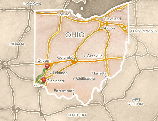
Great Miami Valley
 ABOUT THE ROUTE
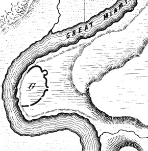
According to the early surveys, the Great Miami Valley was home to a very dense concentration of mounds and earthworks. Squier and Davis’s “Ancient Monuments of the Mississippi Valley” illustrated multiple earthworks, especially between Colerain and Hamilton. None of those remain visible today, although the strangely gated “Fortified Hill” of Butler County survives on a wooded hilltop on private land. Our recommended route spans from Miami Fort, one of the region’s best preserved hilltop enclosures, to the Miamisburg Mound, the most spectacularly sited of the Midwest’s large burial mounds.
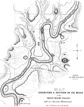
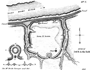
Squier and Davis’s depiction of the string of valley-terrace and hilltop earthworks along the Great Miami River in Butler County, one of the densest concentrations in the region.
 SAYLER PARK AND CLEVES
Take US 50 (River Road) east from downtown Cincinnati, and after several miles reach the pleasant old suburb of Sayler Park. Turn right on Wilkins Short Road for three blocks, then right on Fernbank Avenue until, across the golf course on the left will appear the large, elliptical Short Woods Park Mound. (The much larger Sayler Park Mound was nearby, but excavated and destroyed in the 1950s.) Continue eastward on US 50 to the village of Cleves, where remains of one of the few canal tunnels in America can be seen. It was built in the early 1840s for a canal connecting downtown Cincinnati with Indiana’s Whitewater River. A historical marker near Miami and Wamsley Avenues in Cleves marks access to the partially exposed, eastern entrance of the tunnel, built with Buena Vista stone quarried far away near Portsmouth, Ohio. Only 12 such canal tunnels were built in the US, and only 4 remain; this one is gradually being restored. Leave the village of Cleves via Brower Road; just across US 50 stands the Harrison tomb and monument.
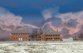
William Henry Harrison was a famous Indian fighter, and the ninth president of the United States. He first came to this area as a young military officer in the 1790s. As an aide de camp to General Anthony Wayne, he fought in the decisive Battle of Fallen Timbers, and was present at the signing of the Treaty of Greenville, which banished local Native people to land far north and west of the Ohio. Harrison served as Secretary, and Congressional Representative, of the Northwest Territory (today’s states of Ohio, Indiana, Illinois, Michigan, Wisconsin, and part of Minnesota). Later appointed by President Adams as its Governor, Harrison encouraged white settlement, while making constant inroads on Native lands. In 1811, he led an army to victory at Prophetstown (in Indiana Territory), where people from many tribes were hoping to unite, under the Shawnee leader Tecumseh, to drive American settlers back. During the War of 1812, Harrison was in charge of defending the Northwest from English and Indian attack. After the war, he made his home in Cleves, and was elected first to Congress, and then to the U.S. presidency. Only a month after taking office in 1841, he died of pneumonia.
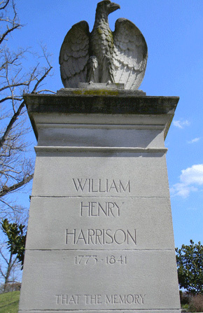
The Harrison monument stands on Brower Road just west of the village of Cleves, marking the tomb of the ninth president of the United States.
 SHAWNEE LOOKOUT PARK, MIAMI FORT
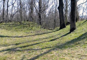
From Harrison’s Tomb, take either the uphill route (Cliff Road) or continue on Brower Road to reach the entrance of Shawnee Lookout Park, the first (and still the largest) archaeological preservation district in Ohio. There are many layers of history here, plus an extremely rich natural area: varieties of fish, plants, game, and waterfowl; with spectacular annual bird migrations. The large Hamilton County park encompasses a golf course and other modern amenities, surrounded by steep bluffs. The winding park drive ends beneath a narrow ridge on which the ancient Ohioans built and maintained for centuries a hilltop enclosure, still well preserved. Trails lead among the walls and gateways, some walls dropping into deep ravines, and some still creating water-holding ponds similar to those at Fort Ancient.
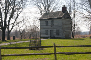
Shawnee Lookout Park also contains pioneer era buildings like this log cabin, and a nearby stone school house.
 MIAMI FORT
The hilltop enclosure called Miami Fort crowns a narrow precipice above the confluence of the Great Miami and Ohio rivers. From these walls the ancient people could look out over the rich marshes and waters below, and may have been able to see sister earthworks across both rivers. Trails follow the well-preserved walls and gateways, into prominent “prow” shapes, and deep ravines, and out to a majestic overlook.
The ancient earthwork at Miami Fort overlooks the site of Fort Finney, built (like Fort Harmar at Marietta) in 1775. Named after the military captain in command, the fort was to provide a place where Shawnee and Miami chiefs could meet and sign a treaty giving up all their land north of the Ohio to the new nation of the United States. The tribes farther east had already been pressured to give up their land, but the Shawnee and Miami here in the west had not.
Ohio Indian Commissioner Richard Butler set a time for a meeting, but most Shawnee and Miami leaders stayed away. Those who showed up at the fort were simply hungry, but when they discovered the agenda, they too rejected it. Here are Shawnee Chief Tame Hawk’s words:
As to the lands, it is all ours. You say you have goods for our women and children; you may keep your goods and give them to other nations, we will have none of them.
The Indians gave Butler a belt of black wampum, symbolizing disagreement. But Butler ground it under his heel, and otherwise convinced the Indians of his power. At last they gave in and signed. The commissioner got his treaty, but since the vast majority of Shawnee and Miami were not there, it turned out to be meaningless.

Play video
Miami Fort is located in Shawnee Lookout Park, a reminder of the Indians who were forced east by the Indian Removal Act of 1830.
Walls of the southeastern prow of the earthwork, near the large level plateau, perhaps human-made, that occupies the eastern end of the main enclosure.
One of the most dramatic features at Miami Fort is a set of stepped ponds along the western enclosure wall, just before the path drops into a steep ravine.
 THE FERNALD PRESERVE
Follow the Great Miami River route (SR 128) north. Between Miamitown and Ross (left on Willey Road) the Fernald Preserve covers a large, flat terrace above the river. The tiny village of Fernald gave its name to the massive, and for a while infamous, uranium refinery built in the early 1950s. Some of the Cold War’s finest uranium was produced here, by workers proud to serve their country’s efforts, willing to keep its secrets, and happy for the prosperity it brought to their community. But after a couple of accidents, rising health concerns, and a national media scandal, a 4.3 billion dollar clean up was begun in the 1980s. Today the land is a restored prairie, more or less as it may have been encountered by the first white settlers in 1806, except that the eerie, rectangular ponds echo the contaminated footprints of the manufacturing plants and waste stockpiles. Much of the radioactive debris was shipped across the country, but much was also sealed in the giant, surreal mound (the “On Site Disposal Facility” or “OSDF” in official Department of Energy parlance) that dominates the eastern horizon here. Earth architecture again speaks of eternity, as the Department of Energy’s Office of Legacy Management will be monitoring the aquifer beneath the mound forever. (10995 Hamilton Cleves Hwy, 513-648-6000)
The beautifully re-purposed warehouse that is now the Fernald Preserve Visitor Center contains exhibits telling the many complex histories of the site.
 DUNLAP'S STATION
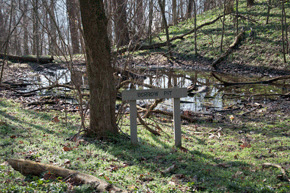
Across the river from Fernald is the historic cemetery for Dunlap’s Station, the site of particularly barbaric clashes, on both sides, during the struggle over southwest Ohio lands. Cross to the east shore of the river on US 27 north of Ross, then head southwest on East Miami River Road for just under 2 miles; the cemetery entrance will be on the right just before Heritage Park.
In the late 1700s, settlers ventured farther and farther north of the Ohio River along the tributary valleys, building cabins, planting crops, grazing cattle, and creating fort-like settlements called “stations” – the most northerly along the Great Miami was Dunlap’s Station, also called “Coleraine.” It was located next to an enormous 95-acre D-shaped Hopewell era enclosure, with walls nine feet high. Yet the settlers became victims of a “most severe attack by Indians” in 1791, who, besides killing and burning, also tortured a captive man to death by setting a fire on his abdomen (the story of his night-long screams became part of Ohio anti-Indian lore). In a similarly savage vein, though, the army lieutenant in charge of defending the station boasted of a set of Indian scalps his men had taken. Today both the ancient Indian enclosure and the fort are long gone, though the cemetery remains.
The ancient earthen enclosure adjacent to the site of Dunlap’s Station, near Ross in Hamilton County, was illustrated by Squier and Davis in 1848.
 WHITE WATER SHAKER VILLAGE
Three miles west of Fernald, along Oxford Road above New Haven, are several surviving buildings from the Central and North Families of the White Water Shaker Village, one of thirteen settlements across New England and the Midwest planned by this industrious nineteenth-century sect. The site is preserved within Miami Whitewater Forest, a county park. A lovely approach is along the park’s Shaker Trace Hike-and-Bike trail. The “Shaker” movement, or “The Believers in the Second Appearance of Christ,” was founded in 1824. The celibate group, known for its shaking religious dances, lived communally here at White Water in three groups called “families.”
Some North Family buildings remain along New Haven Road, notably the only Shaker Meeting House built of brick, and next door, the large North Family dwelling. These Shakers, like their brethren in the east and in Kentucky, thrived through careful farming methods and successful sales of brooms, seeds, and other products, including silk from their own silkworms. The Hamilton County Park District has stabilized 23 Shaker buildings, on view but not yet open to the public.
A mound survives in the New Haven Cemetery, on Oxford Road just south of the South Family buildings.
Computer restoration of two buildings of the North Family cluster, White Water Shaker Village (image by CERHAS University of Cincinnati).
 RENTSCHLER PRESERVE AND ITS EARTHWORKS
About 4 miles northeast of the city of Hamilton’s pretty waterfront and historic downtown, along SR 4, lies the Rentschler Forest Preserve. Enter via Reigart Road for the picturesque canal remnants along the riverbank, from which trails explore the two flat-topped, wooded terraces; the eastern one is the earthwork site. For shorter access to the earthwork, continue along Route 4 to the next intersection (Rentschler Estates Drive) where there’s a parking lot beside an old barn. From here, the “Earthwork Trail” skirts a large meadow before entering the forest, where a small ravine appears on the left. Just beyond, a large section of the earthwork appears among the trees on the right. This is the southern wall of the enclosure, and its most distinctive feature remains intact: a 100-foot earthen ring embraced by two arcs, forming an elaborate entranceway; a bench and small sign provide orientation.
The Squier and Davis plan of the Fairfield Township Earthworks, with its distinctive “parentheses and circle” gateway, now in the Rentschler Forest Preserve.
 CARLISLE FORT EARTHWORKS
Off of SR 4 about 2 miles south of Germantown, the Twin Rivers Metro Park covers bluff land overlooking Twin Creek. A trail from the south parking lot off Chamberlain Road leads to the Carlisle Fort Earthworks, a 3- to 4-foot high, roughly triangular enclosure built in the Hopewell era around a wooded hilltop.
The trail climbs toward an open meadow, then turns right along a well-preserved earthen wall that seems to glide through the woods atop steep, razor-back ridges. Carlisle Fort is little known today, partly because it was not included in Squier and Davis’s Ancient Monuments of the Mississippi Valley, though it was mapped in the 1830s by a physician named Samuel Binkley. An especially impressive prow points to the southeast, down a long ridge. Dr. Jarrod Burks has compared Binkley’s early map with a modern topographic map, and has identified the remnants that are currently visible. Out in the open meadow, remote-sensing surveys have revealed the details of two circles, possibly gateways into the walled promontory.
Today the site is at risk of some severe erosion damage. Dr. Burks:
One unfortunate aspect of Carlisle Fort is, once you see those embankment walls, and you walk them, you notice that they seem to cut across deep ravines. Well, according to Binkley those ravines didn’t used to be there. It was much more continuous back in his day. So this is a site that really exemplifies the amount of erosion that has occurred, even since Europeans first started occupying the land. There are lots of gateways now, natural gateways, so to speak.
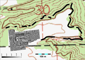
A composite of the USGS map of Carlisle Fort with modern field and remote sensing data (image by Dr. Jarrod Burks).
 MIAMISBURG MOUND
Crowning a hilltop park southeast of Miamisburg’s quaint, historic downtown, the Miamisburg Mound is one of the largest Adena era burial mounds in North America, and certainly the most spectacularly situated. It contains 54,000 cubic yards of earth.
There were two burial vaults: one was 8 feet from the top and contained a bark-covered grave; another was found 36 feet down, a chamber built of logs but containing no skeletal remains. Climbing the 116 steps to the top of the earthwork affords a splendid, clear view of the surrounding 36-acre park, and the Great Miami Valley almost in its entirety from the hills west of Cincinnati to the tops of downtown Dayton’s skyscrapers. The sweeping views suggest why this high, prominent hilltop was important to the builders, and perhaps why they went to all this effort to make it even higher. (The only larger Adena burial mound in existence is the Grave Creek Mound, in Moundsville, West Virginia, located on the Ohio River 15 miles south of Interstate 70 at Wheeling.)
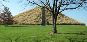
The pure conical form of the Miamisburg Mound stands atop a high bluff, offering views far up and down the Great Miami valley.